The following article was first published in Wild Earth, Vol. 7, #2, pp 62-66, 1997. Some corrections and additional information, usually in brackets, have been introduced into the text.
Geology in Reserve Design,
An Example from the Folded Appalachians
by R. F. Mueller and Gus Mueller
Abstract
A strong relation exists between bedrock geology, forest type, and land use on Warm Springs Mountain in Virginia and by extension in other parts of the folded Appalachians. These relations have important implications in the design of wildland reserves in the region. Most de facto wildlands that are potential reserves are public land, which is a consequence of low biologic productivity associated with refractory bedrock. However, more productive rocks, such as carbonates (limestones, dolomites, and some sandstones and shales), frequently occur on adjacent private lands or as enclaves within public lands. The tracts on which these productive rocks occur should be targeted for protection and restoration as vital complementary parts of the reserves. Geology has an important role in the identification and characterization of this diverse terrain and should be an integral part of reserve planning.
INTRODUCTION
The establishment of wildlands reserves in the Appalachian Mountains requires an appreciation of the ecological functions of the array of forest types and other biologic communities of the region. The varied forest types and plant communities result in part from and interact with enveloping physical systems: rock type and structure, topography, climate, soils, etc. They are an example of the functional landscape mosaic listed by Noss (1995/96) as necessary to reserve viability.
Soils are usually regarded as the most fundamental interface between biologic systems and the physical environment. While this is in a sense true, soils are difficult to work with in the field and represent on maps because they show so much small-scale variation in response to local topography and even recent history of human disturbance. Geologic rock units have an advantage over soil units in that their boundaries may be more easily projected and interpolated. This is especially true of the folded Appalachians where many rock unit boundaries tend to be linear along fixed trends. Also, in colluvial deposits detached rocks may be more easily identified than soils and traced to their points of origin. This relative ease of identification extends to mineral specimens, using no more than a hand lens (for texture), a knife blade (for hardness), and an acid bottle (to test for carbonate). By contrast, soil characterization usually requires lab work. These advantages are particularly important to activists who have little time and few resources. For these reasons we deem bedrock geology a more practical indicator of major regional variations in forest type, and one of our objectives here is to demonstrate the value of geology in regional ecological mapping. Nothing in the foregoing, however, should be seen as diminishing the role of soils. The characteristic of variation in response to local conditions that makes it difficult to map soils is at the same time useful in the interpretation of microhabitats that determine precise locations of species. For example, soil depth and type over limestone governs where alkali or acid-favored species occur. Thus, over limestone bedrock, Chinquapin Oak ( Quercus muehlenbergii), which demands high pH, is favored by shallow soils, while Red Maple (Acer rubrum ), an acid-lover, requires deep and leached soils. Of course, forests also vary in response to such factors as elevation, slope and aspect, which may be independent of geology or show their effects within geologic formations; and indeed these factors have received attention in the region in the past (e.g. Stephenson and Adams 1991). Although the writers know of few specific studies of the relation between forests and geology in the Central Appalachians, this relation is referred to frequently in a general way by Braun (1950) and is implicit in recent works on certain plant distributions. Thus Ogle (1989) discussed the distribution of rare and disjunct plants which occur on certain Ordovician dolomites. Also, the relation is well recognized by the Virginia Natural Heritage Program (Ludwig et al 1994), which has used it in inventories of rare species and unusual communities.
Many of the ranges of the folded Appalachians have an asymmetry with respect to rock type exposure.1 Frequently one side of a range and the summit consists of erosion-resistant and nutrient-poor sandstone or quartzite, while the other side is dominated by limestone, dolomite shale or siltstone in various proportions. Usually carbonate and/or shale also form the floors of the narrow valleys that separate the ranges. The northeast-southwest linear extension of the ranges form fairly extensive de facto wildland corridors in this direction. However habitat continuity in the cross-range direction is frequently interrupted by agricultural development not only in the valleys but also on mid-slopes. Forest types developed on the refractory sandstones and quartzite have important functions as remote habitat, excellent cover (e.g. laurel thickets), and sources of certain important forage such as acorns. However, they are also limited by lack of forage and habitat diversity and productivity. Far different were the original forests that occupied the mid-slope and valley bottoms on the highly productive soils associated with carbonate rocks. These forests consisted not only of a high, complexly structured and diverse mesic canopy, but also a multitude of fruiting and tuber-producing plants, fungi, and resident fauna that provided abundant foraging opportunities for animal life with access to them. The areas once occupied by these forests, but which now possess them only in degraded form if at all, are thus priority targets for ecosystem recovery.
WARMS SPRINGS MOUNTAIN
Warm Springs Mountain extends 28 miles (45 km) northeast from Covington, Virginia. Like a number of similar ranges in this part of the folded Appalachians, it averages about three miles (5 km) in width and is capped by erosion-resistant Silurian sandstone and quartzite. It attains 4000 feet (1220 meters) elevation in several places, with Bald Knob at 4225 ft (1288 meters) being the highest. In terms of geologic structure it is part of an anticlinal fold (folded layers form an upward pointing crest), but this anticline has been breached by erosion over much of its length, exposing older Ordovician rocks that form its core ( Figure 1). The central and oldest of these rocks are limestones and dolomites of the Beekmantown Group and the Moccasin Formation, which underlie the Warm Springs Valley just northwest of the range. Slightly younger carbonate-bearing shales of the Martinsburg Formation form the northwest slope, and these are overlain by shales, siltstones and sandstones of the Juniata Formation. The Juniata is in turn overlain by the Silurian Clinch quartzite of the summit.
A feature of Figure 1 that needs to be clarified is the apparent absence of Silurian rock on the northwest limb of the anticline. This is a consequence of a failure to distinguish the Silurian from lower Devonian in this area as well as the relative thinness of the Silurian ( Rader and Evans 1993).
If the pattern of land ownership (Figure 2) is compared with the distribution of rock types, it appears that correspondence is quite good. Public land, and particularly National Forest, is largely confined to areas underlain by Silurian rocks of low productivity, while limestone and carbonate areas are predominantly in private hands. Where the areas of Silurian age are expanded southwest and northeast of the Ordovician belt (points A and B of Figure 2), the anticline is not breached and the forest cover is similar to that which occurs on the southeast limb (points C, D and E of Figure 2). It should also be noted that in the vicinity of point B the Silurian rocks of the anticline plunge beneath the Devonian as a result of cross deformation. Everywhere on the uplands this forest is dry and ericaceous, consisting dominantly of Chestnut Oak (Quercus prinus ) with lesser amounts of White (Q. alba ), Northern Red (Q. rubra), Black (Q. velutina ) and Scarlet Oak (Q. coccinea), Red Maple (Acer rubrum) and Black Gum (Nyssa sylvatica ). The shrub layer consists largely of Mountain Laurel (Kalmia latifolia), Upland Low Blueberry (Vaccinium pallidum) and Black Huckleberry ( Gaylussacia baccata ). The leaf mat is heavy and ground cover is usually confined to scattered small heaths such as Teaberry (Gaultheria procumbens) and Trailing Arbutus (Epigaea repens ) and herbs such as Wood Tickseed (Coreopsis major). Leucobryum cusion moss and Cladina lichen are common at tree bases and on patches of open ground.
Examples of [at] least one other forest type occur at lower elevations on the silica-rich Silurian rocks. These are the mesic forests along streams and in well-watered coves. Like those of the upland forests, soils are acid, as reflected in both woody vegetation and herbs. The most imposing example is Dolly Ann Hollow (point E, Figure 2). The canopy here is dominated by large old-growth Canada (or Eastern) Hemlock (Tsuga canadensis ), White Pine (Pinus strobus ), White and Chestnut Oaks and Pignut Hickory (Carya glabra ), with smaller sized Black Gum, Northern red Oak, Tuliptree (Liriodendron tulipifera), American Basswood (Tilia americana ) and Shagbark Hickory (Carya ovata). Witch Hazel (Hamamelis viginiana), and especially Great Rhododendron (Rhododendron maximum), form thickets along the stream. The acid and nutrient-poor near-surface soil layers result in sparse herbaceous ground cover and its limitation to a few species such as Partridge Berry (Mitchella repens ). Similar "acid-mesic" forests also occur in coves near location A (Figure 2), but here contain such species as Striped Maple (Acer pensylvanicum ), Canada Mayflower (Maianthemum canadense ) and Starflower [Trientalis borealis ] in response to somewhat higher elevations than at Dolly Ann Hollow. Our point here is that despite abundant moisture in the acid-mesic forests, they differ greatly from the mesic forests on rich or circumneutral soils.
If we now consider the forests developed on carbonate rocks of the Ordovician formations, we see stark differences delineated by geologic boundaries. The richest soils and those most utilized for agriculture, occur on the limestone and dolomite rocks of the Warm Springs Valley along US Route 220 (Figures 1 and 3). Forests here are diverse, with many mesic species such as maples, elms, ashes and Tuliptree: yet they also contain many oaks, due to the ready subsurface drainage of limestone bedrock and the consequent drying of soils during periods of drought. Indeed, this valley is a notable karst area with many sinkholes and caves (Hubbard 1988).
Of greater interest to us than the valley limestones is the Martinsburg Formation because it underlies areas nearer the Silurian rocks and public lands. This formation consists of predominantly "yellow to brown weathering limy shale" with a thickness of about 1000 feet (300 meters). The overlying Juniata formation of 300 to 400 feet (90-120 meters) in thickness forms a narrow transitional zone between carbonate rocks and the Silurian sandstones (Bick 1962). Both of these formations are included under "Ordovician Shale" in Figure 1.
One of the most striking-and accessible-transformations in forest type associated with the contact between two rock units occurs in the high gap by which State Route 39 crosses the range just east of Warm Springs, VA. Here (point F, Figure 2), after passing through oak forest on the southeast slope, is an abrupt change in vegetation at the gap. At almost 3000 ft (914 meters) elevation Black Walnut (Juglans nigra ) and other mesic species, including particularly many grape vines (Vitis aestivalis), suddenly appear. Othe mesic species encountered on descent of the northwest slope are Slippery Elm (Ulmus fulva ), Northern Red and White Oaks, Black Birch (Betula lenta ), Shagbark, Bitternut and Pignut Hickories (Carya ovata, C. cordiformis and C. glabra ), Butternut (Juglans cinerea), Cucumber Magnolia (Magnolia acuminata), White Ash (Fraxinus americana), White Basswood (Tilia heterophylla), Black Cherry (Prunus serotina), Black Locust (Robinia pseudoacacia ), Red, Sugar and Black Maples (Acer rubrum, A. saccharum and A. nigrum ) and Red Mulberry (Morus rubra). Shrubs include Black Elderberry ( Sambucus canadensis), Witch Hazel, maple Leaf Viburnum (Viburnum acerifolium ) and Flowering Raspberry (Rubus odoratus ). Black Maple in particular is considered to be an indicator of the richest (eutrophic) forest type in the state (Rawinski 1994). Martinsburg Shales are conspicuous in road cuts on the slope.
A similar transition of forest types may also be observed in the southern part of the range along State Rout 606. This road ascends the northwest slope obliquely toward a broad wind gap at the range crest. The aspect here varies from west to southwest, but the forest is mesic. Approximately 2 miles (3.2 km) southeast of Route 220 (point G, Figure 2) typical Martinsburg Shale is exposed in a road cut beneath dark brown mull type soil which is characteristic of mixed mesophyte forest. Although this forest is secondary and has suffered obvious degradation, its original character is identifiable. The canopy is dominated by White Ash with subordinate Sugar Maple, Black Locust and a little Northern Red Oak, the most mesic of oaks. As is characteristic of such mesic forest, there is virtually no leaf mat. It appears that the water retaining properties and fertility of the limy shale are, despite the unfavorable aspect, adequate to maintain mesic conditions throughout the year, enabling the observed species to out-compete such oaks as appear on the valley limestones. The mesic character of the forest is maintained to the mountain crest. At this point Route 606 meets Route 703, which follows the ridge to the northeast. The transition from mesic to dry oak forest occurs in 0.3 mile ( 0.5 km) along this road, where it climbs out of he gap and encounters resistant sandstone. The forest here, and extending along the ridge, consists of Chestnut, White and Northern Red Oaks and considerable Red Maple. Mountain Laurel is common in the shrub layer.
Above approximately 3500 feet (1070 meters) this oak forest itself undergoes a transition to predominantly Northern Red Oak, as is usual for higher elevations in the region (Mueller 1996). On the exposed culmination of the ridge at Bald Knob, the oak forest becomes stunted and wind contorted. On the most exposed slopes it gives way to Pitch Pine (Pinus rigida) heath with shrubby Bear Oak ( Quercus ilicifolia), Catawba Rhododendron (Rhododendron catawbiense), Minnie-bush (Menziesia pilosa), Black Chokeberry (Aronia melanocarpa), huckleberry and blueberries. Accompanying these are such boreal species as American Mountain Ash (Pyrus americana ), Canada Mayflower, and the rare Variable Sedge ( Carex polymorpha ).
CONCLUSIONS AND RECOMMENDATIONS
Close correspondence appears to exist between the geology and forest type on Warm Springs Mountain, a fairly typical range of the folded Appalachians. This correspondence includes not only the obvious contrast between valley bottom and ridge top, but also the slope formations. In at least some situations the effect of bedrock dominates that of aspect and other slope factors and may be the primary determinant of forest type distributions. Although the present study was confined to Warm Springs Mountain, a perusal of geologic, land use and forest cover maps, as well as cursory field observation, indicates that similar relations probably occur on many ranges of the folded Appalachians. Specific examples include Peters, Clinch and Walker Mountains in southwest Virginia and ranges to the north and northwest of Warm Springs Mountain. To varying degrees, such relations should occur in unglaciated terrain quite generally, and even in glaciated terrain where bedrock is near the surface. Correlations between fluvial and glacial deposits and forest type have also been recognized, an example being the association of Jack Pine (Pinus banksiana) and glacial outwash (Braun 1950). Relations between fluvial deposits and forest type in the unglaciated Appalachians should be investigated.
This study indicates that geologic formation delineation and trend lines can facilitate ecological mapping. Relations between geologic formation, topography and forest type should also enhance the value of aerial photographs and aid field work. The use of geology thus provides several converging avenues to ecosystem protection and recovery. Although state Natural Heritage programs give most attention to rare species and ecosystems, integration of geology into these programs can help realize the potential of degraded but critical areas in the regional ecologic mosaic. In the absence of geologic information, recognition of such areas and their ecological functions will be more difficult. Consequently, we urge that geologic mapping and formation characterization be incorporated in evaluating ecosystems on a scale much larger than its present incidental use as a guide to certain rare occurrences.
Geological data and concepts should be integrated into wildland planning by activists. An additional benefit of such planning could be the involvement of a larger segment of the scientific community. Many geologists might be surprised to learn that they can make significant contributions to preserving and restoring biodiversity through their knowledge of rock distributions and mineral chemistry. Scientists are ever on the lookout to expand their activities into new fields. Unfortunately, to the present most geologists have been single-mindedly concerned with the exploitation of Nature. This could be changed by revealing to them the role in wildland research and preservation.
Gus Mueller is an artist and writer with an interest in Nature and technology. Bob Mueller, a retired [ NASA ] scientist, is coordinator of Virginians for Wilderness (Rt.1 Box 250 [now 727 Stingy Hollow Road ], Staunton, Virginia 24401).
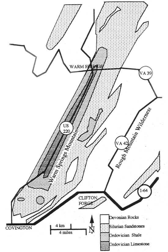
Figure 1. Geology of Warm Springs Mountain and vicinity.
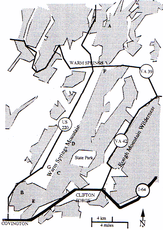
Figure 2. National Forest lands of Warm Springs Mountain and vicinity (in gray).
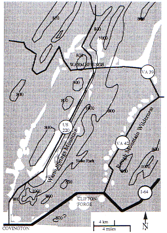
Figure 3. Forest cover (in gray) and 800 and 1000 meter contours of Warm Springs Mountain and vicinity.
Acknowledgement
The writers appreciate the assistance in the field of Steve Krichbaum and Mike Jones. We also appreciate the generous support provided by Humani-tees and The Fund for Wild Nature.
References
Bick, Kenneth F. (1962) Geology of the Williamsville Quadrangle, Virginia. Report of Investigations 2. Virginia Division of Mineral Resources, Charlottesville, Virginia.
Braun, E. Lucy (1950) Deciduous Forests of Eastern North America. Macmillan, New York.
Hubbard, David A. Jr. (1988) Selected Karst Features of the Central Valley and Ridge Province, Virginia. Virginia Division of Mineral Resources, Publication 83.
Ludwig, J. Christopher, Allen Belden and Christopher A. Clampitt (1994) A Natural Heritage Inventory of the Clinch Ranger District, Jefferson National Forest Technical Report # 94-2. Virginia Department of Conservation and Recreation, Division of Natural Heritage.
Mueller, Robert F. (1996) "Central Appalachian Plant Distributions and Forest Types, or what a walk in the woods can tell you." Wild Earth 6 (1), 37-43.
Noss, Reed F. (1995/96) "What Should Endangered Ecosystems Mean to the Wildlands Project?" Wild Earth 5 (4), 20-29.
Ogle, Douglas W. (1989) "Rare Vascular Plants of the Clinch River Gorge Area in Russell County, Virginia," Castanea 53 (2), 105-110.
Rader, E. K. and N. H. Evans, editors (1993) Geologic Map of Virginia-Expanded Explanation. Virginia Division of Mineral Resources, 80 pp.
Rawinski, Thomas J. (1994) A Classification of Virginia's Indigenous Biotic Communities: Vegetated Terrestrial and Estuarine Community Classes, Technical Report # 92-21. Virginia Department of Conservation and Recreation, Division of Natural Heritage.
Stephenson, Steve L. and Harold S. Adams (1991) "Upland Oak Forests of the Ridge and Valley Province in Southwestern Virginia." Virginia Journal of Science 42 (4), 371-380.