R. F. Mueller
-
The Monongahela
National Forest lies in the strategic heart of the Appalachians.
Including parts of the Valley and Ridge Province and the Allegheny
Mountains and Plateau, it is the most promising bastion for
wilderness recovery and big wilderness in the entire Central
Appalachian region. Its 900,000 acres of federal lands could be
doubled through acquisition of wildlands within and adjacent to the
proclamation boundary. It has excellent connections to the million -
acre George Washington National Forest to the east and along the
mountain ridges to Maryland and Pennsylvania State Forests. It is
the regional center and support for the ultimate recovery of
biodiversity in a vast complex of rugged mountains and hills to the
west and southwest.
The Monongahela has inspired several recent proposals for expanded wilderness, in particular Robert Stough's (1990) "Wilderness Manifesto" and Ed Lytwak's (1991) " The Monongahela Forest, An Alternative Vision." It is generally agreed among those who share this vision that we should finish, not with isolated wilderness tracts in otherwise hostile terrain, but with integrated preserves in which wilderness cores are linked by broad migration corridors and enveloped by buffer zones where only low impact human activities occur(1). Advocated particularly by Noss (1983, 1987), the wilderness/corridor system was adapted to the Appalachians by the writer (Mueller,1985) and by Sayen (1987). Recently it has been elaborated for the George Washington National Forest (Mueller, 1991 ) and has been incorporated as an alternative in the pending plan for the GWNF.
Currently there five areas, comprising 78,131 acres, of designated Wilderness in the Monongahela: Cranberry (35,864 acres), Dolly Sods (10,215), Laurel Fork North (6055), Laurel Fork South (5997) and Otter Creek (20,000). Several of these areas, in particular the Cranberry and Otter Creek, would lend themselves to immediate substantial expansion, each perhaps doubling in area. This would be especially easy for the Cranberry Wilderness since the adjacent Cranberry Back Country already has its roads closed to private vehicles. In answer to a recent inquiry, the Forest Service stated (letter, 6 - 3 - 91) that there is currently no roadless area review and evaluation (RARE) study of the Monongahela, and that no formal proposals for additional wilderness have been made by citizens.
The Monongahela varies considerably in terrain and climate, with elevations ranging from less than 1000 feet above sea level near Petersburg, West Virginia to 4862 feet on Spruce Knob. Precipitation increases more than 30 inches per year from east to west so that the linear, folded mountains of the Valley and Ridge lie in the rain shadow of the high Alleghenies. Mean temperatures in the region may vary 10 deg F, with the lowest temperatures in the high valleys where air drains down from the peaks. These variations in climate have created habitat islands in which northern disjuncts or other species formed small isolated populations. Such populations are vulnerable to genetic deterioration and stochastic effects such as localized disturbances.
The parent forest type of the Monongahela is mixed mesophytic and was derived from similar forests that have occupied the Appalachians and other forest centers such as Europe and East Asia since Tertiary times (Braun, 1950) . It shows its most characteristic development at elevations below 2500 feet and in the southern Monongahela. It is diverse with a number of species each of magnolias, oaks, hickories, walnuts, elms, birches, ashes, basswoods, maples, locusts and pines. here also are Tuliptree, Black Gum, Eastern Hemlock, Black Cherry, American Beech and the type indicator Yellow Buckeye. American Chestnut, now stunted by disease, once was a major component. In a mature forest these canopy trees tower over an equally complex understory of small trees and shrubs and an exceedingly rich ground cover of flowering plants, ferns, fungi, etc. On ascent to higher elevations southern species gradually drop out, northern species such as Yellow Birch and Mountain Maple appear, and Sugar Maple, Beech and Eastern Hemlock assume dominance. This is the Hemlock - White Pine - northern Hardwood Forest of Lucy brown. it has a distinctly northern quality in both woody and herbaceous floras and may appear identical to forests of the Adirondack foothills or New England. However, it frequently contains traces of typically Southern and Central Appalachian species such as Fraser and Cucumber Magnolias and black Locust. In some places Great Rhododendron ( Rhododendron maximum) forms heavy understory thickets, a feature uncharacteristic of northern forests.
Above 3500 feet, the northern mixed forest yields gradually to a Red Spruce montane forest of boreal appearance. In this forest, circumpolar flowering plants such as Oxalis montana and Coptis groenlandica or lycopods and mosses dominate the ground cover, while shrubs are rare because of the dense shade. Formerly forest of this kind covered almost 500,000 acres in West Virginia. It is now recovering from the period of destructive logging and fires. Yet this forest is, in biological terms, island habitat.
Toward the east and coinciding roughly with the western edge of the Valley and Ridge Province, where conditions are dryer than in the Alleghenies, there is a broad ecotone between the mixed mesophyte forest and more xeric oak - chestnut type forests of the George Washington National Forest.
Within the large tracts of these major forest types is a considerable number of restricted habitats such as glades (open wetlands or other openings), heath barrens, grass balds, shale barrens, caves and exposed cliffs and peaks. The wetland glades are complex and include sphagnum bogs with peat beds, fens, marshes and shrub and forest swamps. Because of generally high elevations they are home to a wealth of northern species (2), some common, such as cranberries, blueberries, viburnums and hollies, and some rare disjuncts like Bog Rosemary (Andromeda glaucophylla), Buckbean (Menyanthes trifoliata) and Scheuchzeria (Scheuchzeria palustris). Many glades resulted in part from Beaver action and have extensive Speckled Alder (Alnus rugosa) thickets as well as open water or the derivative meadows and successional flora.
The high plateaus of the northern Monongahela and vicinity (Dolly Sods, Roaring Plains etc.) are known for their extensive rocky heath barrens which resulted in part from post - logging fires (Clarkson, 1966). Here in open terrain, wind - shaped "banner" Red Spruce rise among a northern flora that includes Trembling Aspen, Mountain Ash and Mountain Holly (Nemopanthus mucronata) and a variety of characteristic Appalachian heaths such as Mountain Laurel, Minnie - bush (Menziesia pilosa), Great Rhododendron, azaleas, huckleberries etc. The northern components of the Monongahela may comprise as much as ten percent of all native vascular plants of the Forest and a sustatial number of these are at or near their southernmost stations and vulnerable to island effects. Associated northern fauna includes Northern Flying Squirrel, Varying Hare, Fisher and the southernmost breeding grounds for passerines such as the Hermit Thrush, Swainson's Thrush, Purple finch, several warblers, and others. The Canaan Valley (outlined by a dashed line on the map), a premier glade complex at 3200 ft. elevation, contains 40 percent of West Virginia's wetlands. These glades host the southernmost breeding pairs of Common Snipe as well as a disjunct Black Duck population. The Northern Goshawk, a bird of remote northern forests, and the Black - billed Magpie (Pica pica), a western bird, have nested there.
Shale barren floras, concentrated east of the Allegheny Front in the Valley and Ridge Province, are similar to those of the George Washington N. F. in species and adaptation to local hot, dry conditions. Even more restricted are the floras of certain isolated cliffs and peaks such as Panther Knob, which boasts the only occurrence in West Virginia of Michaux's Saxifrage (Saxifraga micauxii) as well as the coastal disjunct False Heather (Hudsonia tomentosa) . Silvery Nailwort (Paronychia argyrocoma) is found only on Tuscarora quartzite, of which the most famous exposure is Seneca Rocks in the North Fork Mountains.
Native diversity and ecological integrity of the Monongahela have undergone considerable diminution since the arrival of Europeans, and this trend continues. We can only wonder what rare endemics might have been lost through logging, fires and agricultural practices that destroyed the very soil of much of the region. It seems possible that some currently rare trees such as Eastern Larch (now confined to the Cranesville Swamp north of the map area), Balsam Fir and Red Pine were more common in the original conifer forest which once dominated the higher elevations. Since the National Forest was established, extensive road building, clearcutting and other developments have diminished, extirpated or possibly extinguished a number of species. An example is the Canada Yew (Taxus canadensis), a northern evergreen shrub which was once common at high elevations but has been virtually extirpated by deer browsing. This is the pattern throughout the Canada Yew's range and has been documented in detail by Alverson, Waller and Solheim (1988 ) in Wisconsin. In all probability, as in Wisconsin, a number of herbaceous plants are at risk of the same fate(3). The timber and "game management" policies have led to this situation through the creation of edge effects and abundant early successional vegetation. In the absence of large predators, edge - dwelling species such as raccoons, opossums and foxes prey upon vulnerable and rare forest interior species.
Seemingly following the early example of Earth First! visionaries, Alverson et al proposed the creation of late successional habitat consisting of 50,00 to 100,000 acre preserves. This would have the effect of diminishing deer food and general edge effects. However they failed to stress the need for large predators. The creation of a number of wilderness preserves in this size range is, as we shall see, possible on the Monongahela. However this step should be regarded merely as a prelude to the complete rewilding of these forests with Cougars, Gray Wolves and other extirpated species.
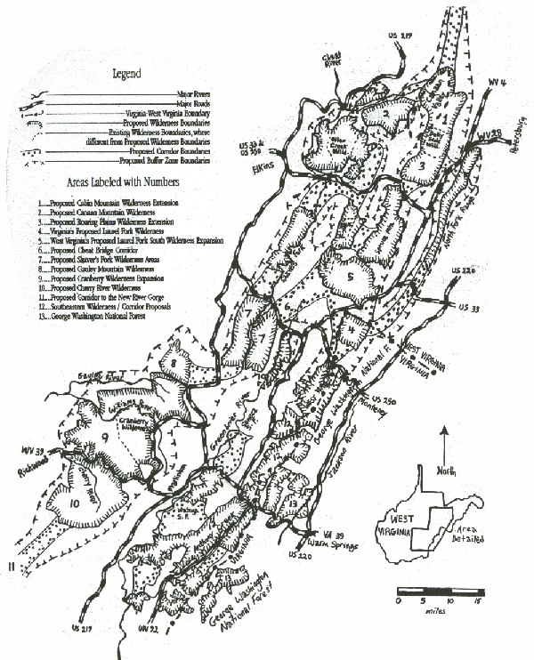
Proposed Wilderness Corridor System
The proposed system consists of 19 new Wilderness Areas and expansions of those already designated. These new and expanded Wildernesses are defined by hatched solid borders on the map. Linking corridors are shown by speckled solid borders and the enveloping buffer zones by hatched dotted borders. Existing Wilderness Areas are defined by thin dotted lines where their boundaries differ from proposed Wilderness Areas. Some areas referred to in the text are indicated on the map by numbers.
The system is concentrated on National Forest tracts, but in certain critical areas is extended to private lands with the assumption that these will be purchased or protected in some other way. The criteria used in drawing boundaries of the three categories are based on existing land ownership, land use and ecological imperatives. Thus, while developed and inhabited areas are for the most part excluded, the extension of important natural features or ecosystems onto private wildlands necessitates that the latter be included. A notable example is the Dolly Sods Wilderness extension along Cabin Mountain 1, encompassing the northern Canaan Valley and associated corridors and buffers, a design with an intent to protect from and purge ski condominium development which threatens the entire watershed. The proposed Wilderness Areas would necessitate closure of a number of Forest System roads, examples being FR 19 on the edge of the existing Dolly Sods Wilderness, FR 112 southwest of Spruce Knob and FR 86 along the Williams River.
Corridors would be managed in much the same way as Wilderness, allowing the forest to revert to old growth under natural disturbance regimes as much as possible. As many corridor roads as possible would be closed. The standards of roads kept open would be scaled back, with reduced width, speed limit and break in forest canopy. Within the buffer zones land disturbing activities would be discouraged and existing developments phased out where possible.
The northern Monongahela and vicinity includes an extraordinary conjunction of habitats and biologic communities to be protected under the proposed system. The system would build on the Dolly Sods and otter Creek Wildernesses. It would extend Dolly Sods along the heath barren plateau of Cabin Mountain and northwestward to include the extensive wetlands of the northern Canaan Valley, where a riverine complex forms an ecotone with a recovering hardwood - conifer forest. Westward from the Canaan Valley a corridor extends along the Blackwater River, a beautiful stream darkened by natural organic pigments(4). This corridor connects to the Canaan Mountain block 2. and from there to the Otter Creek Wilderness which has been expanded to include the critical riparian zones along Glady Fork and an area west of the present boundary.
Southward a broad corridor lies along Laurel Fork and extends to a greatly expanded Laurel Fork north (LF N.) and South (LF. S.) Wilderness Units. To the east short corridor links the proposed Roaring plains 3 and Spruce Mountain Units.
East of the Allegheny Front in the spectacular North Fork range of the Valley and Ridge Province a 30 mile Wilderness/Corridor unit extends from near Pertersburg southwestward to the Virginia line where it joins the proposed Laurel Fork Wilderness of the George Washington National Forest 4. From there a seven mile wide corridor extends northward to the proposed 35.000 acre block of the expanded Laurel Fork South Wilderness centered on Blister Swamp 5. The latter is the site of a disjunct northern plant community including Balsam Fir (5}, which should be top priority for addition to the Forest. From this area a corridor extends to the vicinity of Cheat Bridge 6, a botanical region made famous by the Long - stalked Holly (Ilex collina) and Asa Gray's botanical sweep. In this vicinity, at Blister Run, is one of the planet's southernmost stands of Balsam Fir, which is here reproducing well because deer have abundant alternative browse. This corridor is designed to access two large blocks of proposed Wilderness southwest of Route 250 divided by a railway along Shaver's Fork &. Encompassing the recently acquired 40.000 acre Mower tract addition to the Monongahela, these blocks straddle peaks over 4500 feet in elevation.
From Cheat Mountain a corridor turns sharply west connecting it to the proposed Gauly Mountain Wilderness block 8, which is separated only by a power line right - of - way from the largest possible Wilderness in the Forest, the 100,000 - acre plus Cranberry Wilderness expansion.
The Cranberry block and surroundings include a variety of forest ecosystems ranging from lush mixed mesophyte at lower elevations to pure spruce above 4000 feet. They are known for their abundant glades, as exemplified by the famous Cranberry Botanical Area which lies just outside the existing Cranberry Wilderness. Lying at 3400 feet elevation, it is home to many of the rare and disjunct flora and fauna previously mentioned. However, in common with other areas, it no longer contains Canada Yew. As a result of deer browsing, little or no Yew survives in the Yew Mountains or along Yew Creek!
The Cranberry lies in the highest part of the dissected Allegheny Plateau, which has an extension southwestward of route 39 in the Cherry River drainage 10. In access of 50,000 acres, this block consists entirely of private land within the proclamation boundary and is threatened by proposed coal - fired power plants, mines and transmission lines. It is imperative that it be protected, preferably by addition to the Forest.
From the Cherry River block a broad corridor 11 has been extended open - endedly toward the New River Gorge. With their buffer zones, these areas have a potential of more than 200,000 acres of wildlands divided by only one major highway.
Southeast of the Cranberry - Cherry River complex and the Greenbrier River a salient 12 of the Monongahela extends 30 miles along the Virginia State line in the transition zone between mixed mesophyte and oak - chestnut forest to the east. Most of this forest which, as along Anthony Creek, contains rich mixed mesophyte stands, has been incorporated into nine newly proposed Wilderness Areas. One of these areas, north of Route 39, includes part of the George Washington national Forest 13, and thus forges a wilderness link toward the east.
Summary and Course of Action
The Monongahela National Forest and the highlands of which it forms a part have impressive ecological credentials. In many Eastern forests tends to the cryptic, concealed to the untrained eye in the apparent uniformity of lush deciduous foliage. But in this region diversity is resplendent in contrasting deciduous forest, conifer, glade and other facies that attract an equally diverse fauna. But all this is under threat or actual assault by the perpetrators of an endless variety of despoilation schemes. Heading the list is road - building, with the worst being the infamous "Corridor H" proposal to split the northern part of the Forest with an interstate highway. Road - building is closely followed in destructiveness by power plant and transmission line schemes, one of which would defile the here - proposed Cherry River Wilderness south of Route 39 as well as the Cranberry Wilderness. Other threats come from ongoing ski condominium development, particularly on Cabin Mountain and in Canaan Valley. Finally, forming an ever present backdrop of steady degradation are the misdirected U.S. Forest Service and State management practices. These multiple debasements not only impact the highlands but are in many ways transmitted to remote habitats, from the tropics to the Arctic, through their effects on migrating species. Only ecological restoration and restructuring based on large wilderness can mitigate this deterioration.
A Wilderness/Corridor System as fully developed as this would of necessity be integrated with the regional human culture in a bioregional model (Lytwak, 1991) . Perhaps the best known example of such integration in practice, albeit in its initial stage, is Guanacaste National Park in Costa Rica. As conceived by the biologist Daniel Jansen (Allen, 1988), the primary mission at Guanacaste is the restoration of a tract of tropical dry forest but serving the secondary function of a "living classroom" with the intimate involvement of local human inhabitants in day to day operations. Thus an ecological dimension is given to schooling and employment. Although human cultures in West Virginia and Costa Rica are not directly comparable, they are - like modern cultures everywhere - severed from their ecological roots and generally ignorant of the impact of the machine culture on nature. Consequently the Monongahela Preserve may with equal justification serve as a living classroom. Such a system, consisting of large blocks of unfragmented habitat tending toward maturity and approximating natural disturbance regimes, presents unusual opportunities for scientific baselines against which to measure anthropogenic degradation.
Although the ultimate justification for a Wilderness/Corridor System must be ecological and ethical, economic concerns also need to be addressed if the system is to succeed. As in the Guanacoste example, employment opportunities would be created for local inhabitants. Some of this employment would be ecological restoration; while more would result from accommodating and guiding tourists, students, scientists and other research personnel. New businesses and employment would be created by privatization and moving concentrated recreation facilities, such as developed campsites, from public to private lands. Zoning regulations would maintain standards comparable to the public facilities vacated or supplanted.
What Wilderness proponents Are Doing
Proponents of wilderness are writing letters to: the Supervisor, Monongahela National Forest (200 Sycamore St., Elkins, West Virginia 26241) ; Governor [ Robert Wise ] (State Capitol of West Virginia, Charleston, West Virginia 25305) ; Representatives (U.S. House of Representatives, Washington, D.C. 20515) and Senators (U.S. Senate Building, Washington D.C. 20510) . They are asking that the Monongahela National Forest be planned as a Wilderness/Corridor System to restore and protect its biodiversity and evolutionary potential and to allow for the migration of species as required by global warming. In addition, they are telling the Governor to scrap any Corridor H highway and to ban mineral development in the region.
Larger maps: medium; large
Acknowledgements
The writer appreciates the assistance in the field and the numerous discussions with Mike Jones, Steve Krichbaum and Gus Mueller. Gus Mueller assisted with the map.
References
Allen, William H., 1988, "Biocultural Restoration of a Tropical Forest," Bioscience, 38 (3): pages 156 - 161.
Alverson, William S., Donald M. waller and Stephen L. Solheim, 1988, "Forests too Deer: Edge Effects in Northern Wisconsin," Conservation Biology, 2 (4): pages 348 - 358.
Braun, E. Lucy, 1950, Deciduous Forests of Eastern North America, Macmillan, New York.
Clarkson, Roy B.,1966, "The Vascular Flora of the Monongahela National Foest, West Virginia," Castanea 31 (1): pages 1 - 119.
Lytwak, Ed, 1991, "The Monongahela Forest, An Alternative Vision", Preserve Appalachian Wilderness (Journal) 1 (1): pages 39 - 42 - 53.
Mueller, R. F., 1991), "The George Washington National Forest, Central Appalachian Wilderness in Perspective," Wild Earth, 1 (3): pages 62 - 67.
Mueller, R. F., 1985, "Ecological Preserves for the Eastern Mountains," Earth First! 5 (8): pages 20 - 21.
Noss, R. F., 1983, "Proposal for a Deciduous Forest Ecosystem Preserve," Earth First! 3 (3): page 6.
Noss, R. F.,1987, "Protecting Natural Areas in Fragmented Landscapes," Natural Areas Journal, 7 (1): pages 2 - 13.
Sayen, Jamie, 1987, "The Appalachian Mountains, Vision and Wilderness," Earth First! 7 (5): pages 26 - 30.
Stough, Robert, 1990, "A Wilderness Manifesto," The Highlands Voice, 23 (1): pages 3 and 6.
Strausbaugh, P. D. and Earl L. Core, 1977, Flora of West Virginia (second edition), Seneca Books Inc., Grantsville, West Virginia.
Footnotes
- As pointed
out by Jeff Elliott (Manuscript) Even the Wilderness/Corridor
System has severe inadequacies and may fail its assigned function.
Continuous wilderness may be the only successful scheme!
-
A useful guide here
is the Flora of West Virginia (second edition) by
Strausbaugh and Core (1977) .
-
Monongahela
foresters find the Yew situation embarrassing and have failed to
list it as a sensitive species in their Forest Plan even though it
is far more sensitive than most they do list.
-
Unfortunately the
immediate vicinity of this stream, which is owned by the Monongahela
Power Company, is being severely degraded by ORV bubbas.
- (5) This community, which is severely degraded by deer browsing, clearly reveals the population dynamics of changing White - tailed Deer and Beaver occupancy during the last hundred years.