|
|
|
GPS calculations
Saturday, June 28 2008
Over a year ago, Gretchen and I began the process of going in with our neighbors on the purchase of a 14 acre strip of forest behind our properties. In the end, 12 of those acres became ours and two of those acres became went to our neighbors, but that was after a long interim period that had included a survey. We hadn't hired the surveyor, and looking at his work on the ground and in his plot maps, I can't say I was impressed with his work. He'd decided that existing iron rods were, in some cases, 35 feet from where they should be and identified iron rods that I've never been able to find. Now that I had a metal detector and a GPS gizmo, I was equipped to track down the most maddening of the elusive iron rods, one that supposedly defines the point where three properties meet: our property, that of our downhill neighbors, and a 40 acre forest lot belonging to the Gill corn farming family of the Esopus Valley. When one is trying to find an iron rod shown on a plot map using GPS and a metal detector, this is the general procedure:
- Go to a known border point shown on the plot map (preferably one with a measured distance and bearing to the mystery rod) and, using GPS, get its latitude and longitude.
- Use some sort of calculator to translate a latitude, longitude, distance, and bearing into a second latitude and longitude.
- Use the GPS to find that second location, and then start hunting for the rod with your metal detector.
I'd expected to find a javascript-based calculator on the web to help me with step #2, but none of the calculators I found were easy to use. There's one that can take latitude, longitude, bearing and distance, but it needs the lat/lon data in the archaic degrees/minutes/seconds format (as opposed to the more GPS-friendly degrees.decimal_degrees format). And it only accepts distances in kilometers.
So I ended up using a tool that calculates distance and bearing using two lat/lon coordinates and using successive approximation to find the second lat/lon pair. As presented, this tool was overly-complicated and not suited to the sort of rapid-fire interactivity that successive approximation requires, so I built my own stripped-down version. Out in the forest, I was unable to find any iron survey stakes, but this was partly because I'd misread a distance on the map. It also turned out that plot maps give bearings with respect to magnetic north, not true north, something that struck me as even more archaic than degrees/minutes/seconds. Remember, magnetic north isn't just different from one place to the next; it also changes over time! So I had to correct all the bearings on the plot map by subtracting away the declination. Happily, there's is an easy online tool for determining local declination for a given day.
As always for one of my big projects, I'm continuing to tinker with the new kitchen stove hood, much to Gretchen's consternation. Here are a couple pictures of the kitchen, the first from January 2004 and the second taken this evening.
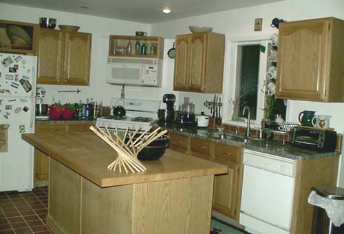
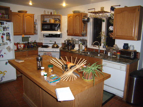
You can see the recent changes to the corner above the stove and the "new" black microwave oven. You can also see the new storage shelf (already occupied with pots) opening through the false wall between the stovetop and the microwave oven. Much of the rest of the kitchen is virtually unchanged from the 2004 version, and the similarities are more striking than the differences. Many things look to have barely moved. The refrigerator was replaced with a more efficient model (the kind with a freezer on the bottom instead of on the top), I added copper pipe wine glass rack high above the sink, and (just today) I added some places to hang colanders. Note that the fruit basket once was a mirror image of itself (it's possible to switch it back and forth by repivoting the constituent sticks; a trip through the fourth dimension is unnecessary). The aloe plant was a recent gift from Ray and Nancy, who had also given us the similarly-shaped fruit bowl.
For linking purposes this article's URL is:
http://asecular.com/blog.php?080628 feedback
previous | next |